

Marine Ecology and Acoustics Lab


Overview
The Arctic Coastal Ecosystems Survey (ACES) is a multi-faceted field and laboratory-based survey aimed at improving our understanding of the importance of the nearshore in structuring the distribution and abundance of invertebrates and nekton. We will examine coastal barrier-island systems (henceforth termed lagoons) and nearshore habitats (offshore out to 15 m isobaths) with the following objectives in mind.
1) Evaluate habitat-specific distribution and relative abundance of fishes, macro-zooplankton and epifauna associated with Arctic lagoons and nearshore habitats;
2) Quantify and contrast age structure and size of fishes associated with lagoon and nearshore habitats;
3) Describe feeding preferences, energy content, and nutritional condition of the dominant organisms from both lagoon and nearshore habitats;
4) Examine the trophic ecology and the significance of marine or freshwater prey to the dominant fishes, and examine connectivity pathways between lagoon and nearshore habitats.

Sampling Locations
The region surrounding Point Barrow offers a unique opportunity to compare communities of three water masses (Chukchi Sea, Beaufort Sea, Elson Lagoon) that are distinct despite their close proximity (Fig 1). Our sampling strategy uses a variety of net-based methods, active acoustics, CTD casts and oceanographic moorings to build a broad dataset that will allow us to compare and contrast observations from several ecological approaches.
Sampling stations were arranged on a grid-based design with transects running perpendicular to the shore out to the 15m isobaths. Active acoustics are used along the entire length of these transects. Sampling stations where biological plankton and fish samples are collected and CTD casts are performed are marked on the map (Fig 1) by green dots. Along the shore, at the origins of the transects are the beach seine sampling stations where the seasonal component of our study is focused. The large yellow dots indicate the locations of long-term oceanographic moorings.
Figure 1. Study design for vessel-based surveys, including acoustic transect lines and oceanographic moorings.
Field Methods
Net-based surveys- At the trawling stations a combination of Tucker trawls, zooplankton casts (Calvet net in deep water, ring net in shallow water), otter trawls, and an Aluette mid-water trawl are used to collect invertebrates and ichtyofauna throughout the water column. Aside from using this catch data to analyze patterns in distribution and abundance, biological samples are retained for an array of laboratory based analyses to assess energetic condition, age structure and trophodynamics. In the nearshore, we use beach seines for macroinvertebrates and ichtyofauna, and a ringnet for plankton. These nearshore samples used in similar ways as the offshore samples, but with the addition of a seasonal component.
Active acoustics- An acoustic survey takes places along the
transects identified in Fig 1 using a Simrad EK60 echosounder.
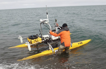
Figure 2. The ASV NANUQ being prepped for launch at one of our Point Barrow nearshore sampling stations.
This data wil provide important information about the distribution and abundance of fish in relation to depth, distance from shore, and bathymetric features. In the nearshore sites where the trawling boat is limited, we use the Autonomous Survey Vessel (ASV) NANUQ (Fig 2). The ASV NANUQ is equipped with an EK60, a Sound Metrics DIDSON imaging sonar, and a Kongsberg M3 multi-beam, and is capable of collecting data autonomously along pre-programmed transects. The DIDSON and M3 offer added information on bottom type and can be used for habitat mapping, which will be factored into our data analyses.
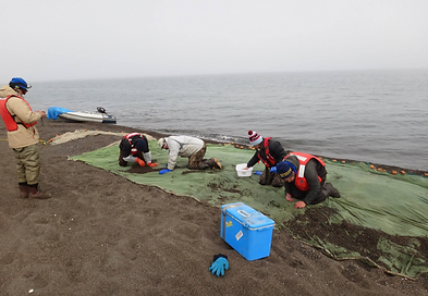
Figure 3. The beach seine crew scours the net after a haul to find all of the fish and invertebrates that were caught. Much of our catch is often tiny larval and juvenile fish, so this technique is necessary to make sure we find everything.
Oceanographic Moorings- Moorings equipped with Acoustic Doppler Current Profilers (ADCP) are placed strategically to measure physicochemical parameters and current direction and velocity at key locations. This information will help elucidate relationships between communities in the different water masses, planktonic dispersal, and other important physical drivers in structuring the nearshore community.
Seasonal Component- Beach seining stations are sampled every week for approximately 6 weeks following ice-breakup, allowing us to identify seasonal trends in community structure, energetic condition, and trophodynamics (Figure 3). During each sampling event fish are retained for laboratory analyses and physicochemical parameters are recorded. Furthermore, zooplankton is sampled using a 500μm ring net towed at the surface, Suspended Particulate Organic Material (SPOM) is sampled by filtering water through a series of stacked sieves (300μm, 100μm, 20μm); these latter measures will offer insight to the seasonal availability of low trophic level food resources.